
The Garmin ECHOMAP UHD2 73sv is an advanced fish finder chartplotter combo designed for anglers and boaters seeking detailed underwater imaging and navigation ease.
It features a 7-inch touchscreen display, which is both user-friendly and offers high-resolution clarity. The device is equipped with a GT54UHD transducer for Ultra High Definition SideVu (Side Imaging) and ClearVu (Down Imaging), providing clear images of structure and fish. This model also includes Garmin’s exclusive Vivid color palettes for enhanced sonar display.
Additionally, the ECHOMAP UHD2 73sv supports the Garmin Navionics Plus cartography, which includes detailed inland or coastal charts and innovative features like Auto Guidance.
The device’s versatility, high-quality sonar capabilities, and ease of use make it a valuable tool for both recreational and serious anglers.
Key Specifications:
| Specification | Detail |
| Display Size | 7 inches |
| Resolution | 800 x 480 |
| Sonar Technology | CHIRP Sonar, ClearVu, SideVu |
| Transducer | GT54UHD |
| Frequencies | 50/77/83/200/455/800/1000/1200 kHz |
| GPS | Built-in |
| Waterproof Rating | IPX7 |
| Price (MSRP) | $949.99 USD |
Pros:
- High-Resolution Display: 7-inch touchscreen offers clear, detailed visuals.
- User-Friendly Interface: Intuitive touchscreen with key assist for easy operation.
- Advanced Sonar Capabilities: Includes Ultra high-defininition SideVu, ClearVu and CHIRP sonar.
- Vivid Color Palettes: Enhances the display for better differentiation of underwater structures and fish.
- Garmin Navionics Plus: Provides comprehensive and detailed charts with features like Auto Guidance.
- QuickDraw Contours: Users can create custom fishing maps with 1-foot contours.
- Wireless Connectivity: Wirelessly connects with other ECHOMAP units sharing sonar data.
Cons:
- Expensive: Might be on the higher end for casual users.
- Small Screen Size: The 7-inch screen size is a bit small for identifying fine details and split-screen views.
- Battery Consumption: High-resolution displays and advanced sonar consume more power, affecting battery life in portable setups.
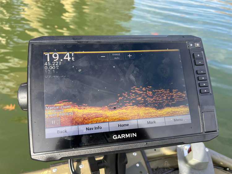
Display Quality
The display of the Garmin ECHOMAP UHD2 73sv is a standout feature, characterized by several key attributes:
- Size: With a 7-inch screen, it offers a generous viewing area, making it easier to read and interpret data.
- Resolution and Clarity: The high-resolution display ensures that details are sharp and clear. This is particularly beneficial when viewing detailed sonar returns, maps, or navigating through menus.
- Touchscreen Interface: The touchscreen functionality provides a user-friendly experience, allowing for quick and intuitive interaction with the device’s various features. This includes zooming in and out of charts and easily switching between different sonar views.
- Visibility: The screen is designed to be visible in various lighting conditions, including bright sunlight, which is essential for outdoor use on the water.
- Color Schemes: The fish finder offers a variety of color palettes for the interpretation of sonar data. It allows users to choose the one that best fits the lighting conditions, water type, and personal preference. The color schemes offered help in distinguishing between hard and soft bottoms or in identifying fish more easily against various backgrounds.
- Split-Screen Capability: This feature enables users to view multiple types of data simultaneously, such as chart and sonar information, which is a significant advantage for navigation and fishing.
The 7-inch screen of ECHOMAP UHD2, while advantageous in many ways, also comes with certain limitations:
- Reduced Detail in Split-Screen Mode: When using split-screen features, each section becomes smaller, which can make it harder to see fine details, especially for complex sonar images or detailed charts.
- Less Ideal for Larger Boats: In larger vessels, where the helm or navigation area is more spacious, a 7-inch screen might be too small to view comfortably from a distance, making larger screens a preferable option.
- Overcrowding with Data Overlays: When overlaying data such as water depth, temperature, and speed, the screen can become crowded, making it difficult to quickly interpret the information.
GT54UHD Transducer
GT54UHD is the compatible Garmin transducer with ECHOMAP UHD2 73SV. It is a versatile, all-in-one sonar solution designed for a wide range of fishing and boating applications. Here’s an overview of its key features and capabilities:
- All-in-One Functionality: The GT54UHD is an all-in-one transducer, capable of performing traditional 2D sonar, side imaging, and down imaging. This multi-function capability makes it a versatile choice for various types of fishing and underwater exploration.
- Traditional 2D CHIRP Sonar: It uses CHIRP (Compressed High-Intensity Radiated Pulse) technology for the traditional 2D sonar, providing clearer fish arches and target separation. This is ideal for identifying fish and structure directly beneath your boat.
- SideVu: The GT54UHD offers SideVu scanning at frequencies of either 455 kHz or 1,120 kHz. This feature is useful for getting a detailed view of the underwater environment on either side of the boat, helping to locate fish and structures with precision.
- ClearVu: The ClearVu operates at a frequency of 800 kHz, providing detailed images of the structure and contours directly below the boat.
- Depth Capabilities: The GT54UHD has the following maximum depths:
- Traditional CHIRP: 800 feet (243 meters)
- UHD ClearVü: 200 feet (60 meters)
- UHD SideVü: 125 feet (38 meters) to each side
- SideVü: 500 feet (150 meters) to each side
- Power Rating: The GT54UHD has a power output of 350 watts, which is sufficient for clear imaging in a variety of water conditions and depths.
- Application: The GT54UHD is suitable for anglers and boaters who require detailed images of the underwater terrain and fish. Its capability to provide high-definition images makes it an excellent tool for both recreational and competitive fishing.
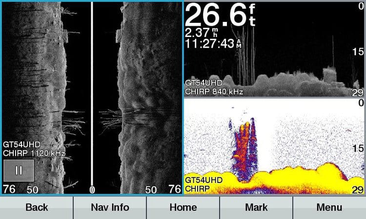
SideVu Performance
The SideVu scanning on the Garmin ECHOMAP UHD2 73SV with GT54UHD transducer provides detailed view of the underwater environment to the sides of the boat. Here’s a review of its performance:
- Fine details at high-frequency: At 1120 kHz, finer details like grass points, bottom composition, and fish are more visible. This frequency provides sharp detail and better contrast, especially in shallower parts of the water. The 455 kHz frequency shows a brighter image in shallow water but lacks the detail seen in 1120 kHz. For instance, details like dimples in the mud and the contrast in fish are less visible. The grass appears more mottled and less detailed.
- Effective Rage: We have found the optimal performance of SideVu scanning is within a range of 50 to 70 feet. This limitation is more about the transducer’s capabilities rather than the settings themselves. In deeper waters beyond this range, the effectiveness may decrease.
- Screen Setup and Resolution: For the best imaging experience, it’s recommended to use the full screen for SideVu scanning. This setup enhances the detail and clarity of the images, making it easier to identify structures and fish.
- Customization: The ECHOMAP UHD2 73sv allows users to adjust various SideVu settings to suit their specific needs. This means you can modify how the sonar data is displayed based on factors like the type of water you’re fishing in (freshwater or saltwater), the depth, and even the type of fish you’re targeting.
- Advanced Settings: Settings like Interference and Time Variable Gain (TVG) can be adjusted to reduce clutter and improve image quality.
Overall, the SideVu Imaging of the ECHOMAP UHD2 73SV with the GT54UHD transducer is well-suited for anglers and boaters looking for quality side imaging at a reasonable price. It strikes a good balance between detail, range, and user-friendliness, making it a popular choice among its users.
ClearVu Performance
The ClearVü performance of the Garmin ECHOMAP UHD2 73SV when paired with the GT54UHD transducer can be analyzed considering the specific characteristics and capabilities of both the device and the transducer:
- Frequency and Sonar Resolution: The GT54UHD transducer provides ClearVu at a single frequency of 800 kHz. This higher frequency is adept at delivering high-resolution images, making it easier to distinguish fish from structure and the bottom. The clarity at this frequency is generally good, offering detailed views of underwater features.
- Limitations in Depth Penetration: While 840 kHz offers high-resolution imaging, it also comes with a limitation in terms of penetration depth. Higher frequencies like 840 kHz don’t penetrate as deeply as lower frequencies. Therefore, while the ClearVü function provides detailed images, it may not be as effective in very deep water environments.
- Ideal for Shallow Waters: Given its depth capability and resolution, the ClearVü scanning is particularly well-suited for mid-depth fishing environments. It’s ideal for anglers targeting structures or fish in freshwater lakes, rivers, and inshore areas where the depth is within the 200-feet range.
- User Experience: The ECHOMAP UHD2 73SV is known for its user-friendly interface, enhancing the usability of the ClearVü feature. Anglers can easily interpret the detailed images making it simpler to identify targets and underwater structures.
In summary, the ClearVü Imaging of the ECHOMAP UHD2 73SV with the GT54UHD transducer is marked by its high-resolution imaging capability at a moderate depth range. It is particularly effective in environments where detailed imaging up to 200 feet is sufficient, making it a valuable tool for a freshwater anglers.
Maps
The Garmin’s ECHOMAP UHD2 73SV fish finder chartplotter combo comes preloaded with Navionics+ charts. Here is an overview of its mapping capabilities:
- Extensive Coverage: Navionics+ provides detailed charts covering a wide range of areas, including numerous lakes, rivers, and coastal regions. This broad coverage is beneficial for both inland and coastal navigation.
- Depth Contours: One of the key features of Navionics+ is its detailed depth contours. These contours can be as precise as one-foot intervals, providing critical information for safe navigation and effective fishing.
- Depth Range Shading: This feature allows users to assign colors to different depth ranges, making it easier to quickly identify specific depth zones. This is particularly useful for anglers looking to target specific depths where fish are likely to be found, or for navigators wanting to avoid certain depths for safety.
- Shallow Water Shading: It highlights shallow water areas on the map, which is essential for safe navigation. By clearly marking shallow regions, boaters can avoid potential hazards and navigate more safely in coastal or inland waters.
- Raster Cartography: This type of cartography displays charts that are essentially electronic versions of paper charts, providing a traditional look and feel.
- Auto Guidance Technology: This feature suggests the best navigation paths based on your boat’s specifications and a chosen destination. It simplifies route planning, especially in unfamiliar waters.
- Dock-to-Dock Autorouting: This feature creates detailed routes from a real start point to a real end point, considering chart data and navigation aids. It simplifies route creation significantly.
- Community Edits: Users can benefit from community-sourced input. This feature includes data from fellow boaters regarding local points of interest, hazards, and other useful navigation information.
Livescope Compatibility
The integration of LiveScope live-scanning sonar in the ECHOMAP UHD2 73SV significantly enhances the fishing and boating experience. It provides real-time, detailed, and dynamic underwater imaging, which is invaluable for effective fishing, safe navigation, and an enriched overall experience on the water.
5 benefits of adding LiveScope to ECHOMAP UHD2 73SV:
- Real-Time Sonar Imaging: LiveScope provides real-time sonar images of what’s happening underwater. This feature allows you to see fish swimming, reacting to your bait, and even see their movement in relation to underwater structures or the bottom.
- Enhanced Fish Targeting: The ability to see fish and their movements in real time significantly enhances your ability to target them effectively. You can adjust your technique, bait, and approach based on the immediate feedback you receive from the sonar.
- Detailed Environmental Awareness: LiveScope sonar offers detailed views of underwater structures, vegetation, and bottom contours. This detailed awareness helps in understanding the underwater environment better, which is crucial for successful fishing and safe navigation.
- Dynamic Perspective: LiveScope offers different viewing modes (like forward and down), providing different perspectives of the underwater world. This flexibility allows you to tailor the sonar view to your current fishing strategy or requirement.
- Enhanced Boat Positioning: Real-time imaging helps in better positioning your boat relative to fish and underwater features. This can be critical in strategy-intensive fishing techniques like jigging or when fishing in areas with lots of underwater structures.
The Garmin LiveScope sonar system must be purchased separately. The system typically includes the LiveScope transducer, the GLS 10 sonar black box, and necessary cables.
Ice Fishing Bundle
Garmin ECHOMAP UHD2 73sv Ice Fishing Bundle is a comprehensive solution for ice anglers, offering high-quality sonar capabilities, detailed mapping, and portability, all tailored to the specific demands of ice fishing. Here’s an overview of what this bundle offers:
- GT10HN-IF Transducer: This high-narrow beam ice fishing transducer provides clear and precise fish arches and excellent target separation. It’s optimized for ice fishing and works well in both shallow and deeper waters.
- Portable Kit: The ice fishing bundle typically includes a portable kit, which makes it easy to carry the device and all necessary components on the ice. The kit often features a rugged, glove-friendly carrying case to protect the device in cold weather conditions.
- Built-In Flasher: For traditional ice fishing sonar view, the ECHOMAP UHD2 73sv includes a built-in flasher, providing real-time data about fish passing through a chosen depth range.
- Battery and Charger: To ensure usability in remote ice fishing locations, the bundle includes a rechargeable battery with a charger. This is crucial for extended trips where access to power might be limited.
- Customizable Mounting Options: The bundle usually comes with various mounting options for the transducer, making it adaptable to different ice fishing setups.
- Preloaded Navioics+ Maps: The unit comes with preloaded Navionics+ Inland maps, offering detailed contours for thousands of lakes. This feature is particularly beneficial for ice anglers to identify potential hotspots under the ice.
- Panoptix LiveScope Support: The ECHOMAP UHD2 73sv is compatible with Panoptix LiveScope systems (sold separately), offering real-time sonar images. This is a significant advantage for ice anglers, as it allows them to see fish and structure in real-time under the ice.
Is Garmin ECHOMAP UHD2 73SV worth the money?
The Garmin ECHOMAP UHD2 73SV, priced at $949.99 (MSRP) could be worth it for the following types of anglers:
- Freshwater Anglers: With SideVu and ClearVu sonar capabilities, it’s ideal for those fishing in freshwater lakes, rivers, and inshore areas. The SideVu is optimal for scanning up to 70 feet, making it great for targeting structures or fish in mid-depth environments.
- Anglers Focusing on Detail: The high-frequency sonar (1120 kHz for SideVu and 800 kHz for ClearVu) offers fine details and better contrast, ideal for anglers who prioritize clear imaging of underwater features, including grass points, bottom composition, and fish.
- Navigators and Route Planners: The preloaded Navionics+ charts with detailed depth contours, depth range shading, and dock-to-dock autorouting are beneficial for boaters who need accurate navigation and route planning.
- Tech-Savvy Anglers: The device’s user-friendly interface and compatibility with LiveScope sonar make it a good choice for anglers who enjoy using advanced technology to enhance their fishing experience.
However, there are some limitations inherent in this unit that should be noted:
- Limited Deep Water Performance: While it offers great detail in shallower waters, the performance in very deep water might be limited due to the high-frequency sonar.
- Additional Costs for Full Functionality: To utilize certain features like the LiveScope system, additional purchases are necessary.
- Overkill for Casual Use: For casual anglers or those who fish in less demanding environments, the advanced features might be more than what’s needed.
If you are an avid angler or boater who frequently navigates diverse water conditions and requires detailed sonar imaging and mapping capabilities, the ECHOMAP UHD2 73SV can be a valuable tool that justifies its cost. However, for casual users or those primarily fishing in shallow waters without the need for advanced navigation features, there may be more cost-effective fish finders that meet your needs.
Variants of Garmin ECHOMAP UHD2 7
The ECHOMAP UHD2 series is a line of chartplotters made by Garmin. It includes several 7-inch models with distinct features tailored to different needs. Here’s an overview of the ECHOMAP UHD2 74SV, 73CV, and 74CV models, along with how they differ from the 73SV:
ECHOMAP UHD2 74SV
- Sonar Capabilities: Similar to the 73SV, it offers traditional CHIRP, ClearVü, and SideVü scanning sonar.
- Mapping: The key difference lies in its preloaded Navionics+ coastal charts, making it more suitable for coastal anglers.
- Target Audience: Designed for anglers and boaters who frequent coastal and offshore waters.
ECHOMAP UHD2 73CV
- Sonar Capabilities: Includes traditional CHIRP and ClearVü scanning sonar but lacks the SideVü scanning sonar found in the 73SV.
- Mapping: Like the 73SV, it comes with preloaded Navionics+ Inland inland maps.
- Target Audience: Anglers who primarily fish in inland waters and don’t require SideVü scanning.
ECHOMAP UHD2 74CV
- Sonar Capabilities: Offers traditional CHIRP and ClearVü scanning sonar. Similar to the 73CV, it does not include SideVü scanning.
- Mapping: Equipped with Navionics+ coastal charts instead of inland maps, targeting coastal and offshore environments.
- Target Audience: Boaters and anglers who navigate coastal areas but don’t need SideVü scanning.
Key Differences
- Sonar Features: The SV models (73SV and 74SV) include SideVü scanning, while the CV models (73CV and 74CV) do not.
- Mapping Software: The 73 models (73SV and 73CV) are geared towards inland fishing with their Navionics+ Inland maps, whereas the 74 models (74SV and 74CV) cater to coastal and offshore activities with Navionics+ coastal charts.
Each variant in the ECHOMAP UHD2 7 series is designed to cater to specific angling and boating preferences, whether inland or coastal, with different combinations of sonar capabilities and mapping software.
FAQs
What are the mounting options of the ECHOMAP UHD2 73SV display unit?
The ECHOMAP UHD2 73SV offers several mounting options to accommodate various boat layouts and user preferences. These options typically include:
- Flush Mount: This option allows the unit to be integrated directly into the boat’s dashboard, providing a sleek and clean look. It’s a popular choice for a permanent, streamlined installation. The unit sits almost level with the dashboard surface.
- Bail Mount (also known as Gimbal Mount): This is a more traditional and versatile mounting option. The bail mount allows the unit to be attached on top of the dashboard or another flat surface. It provides the flexibility to tilt and swivel the display for better viewing angles. This method is ideal for those who prefer an easily adjustable and removable setup.
- U-Shape Mount: Similar to the bail mount, this option offers flexibility in viewing angles and can be installed on a flat surface. It’s another form of gimbal mount but with a slightly different design.
- RAM Mounting Solutions: RAM mounts offer additional flexibility and sturdiness. They are third-party mounting solutions that can be used for more customized mounting positions and are known for their durability and adjustability.
- Portable Kit: For anglers and boaters who prefer a mobile solution, a portable kit can be used. This kit typically includes a carrying case, a portable mount, a rechargeable battery, and a charger. It’s ideal for use in smaller boats or for those who frequently move their equipment between different vessels.
How to Setup ECHOMAP UHD2 73SV?
Setting up the Garmin ECHOMAP UHD2 73SV can be straightforward, even for beginners. Here’s a simplified guide:
Setting Up the Power
- Find the Power Cable: Your ECHOMAP comes with a power cable that has two wires – one red and one black.
- Connect to Battery: Attach the red wire to the positive (+) terminal of your boat’s battery and the black wire to the negative (-) terminal.
- Plug into Your Device: On the back of your ECHOMAP, there’s a port labeled ‘POWER’. Plug the other end of the power cable here.
- Secure the Cable: There’s a ring on the cable’s plug. Turn it clockwise until it’s tight to ensure the cable doesn’t come loose.
Connecting the Transducer
The transducer is what scans the water beneath your boat.
- Install the Transducer: Follow the instructions that came with the transducer to attach it to your boat. It should be in water and away from any motor noise or turbulence.
- Run the Cable to the ECHOMAP Unit: Take the cable from the transducer and run it to where you’ve placed your ECHOMAP unit.
- Plug it In: On the back of the unit, find the port labeled ‘SONAR’. Connect the transducer cable here.
Tips for a Smooth Setup
- Keep Connectors Covered: If there are any ports on the back of your device you’re not using, cover them to protect them from the elements.
- Secure All Cables: Make sure all cables are run neatly and secured, so they don’t move around or get damaged.
- Check for Updates: Once you’re set up, it might be a good idea to check if there are any software updates for your ECHOMAP unit for optimal performance.
How to Use Garmin ECHOMAP UHD2 73SV?
Using the Garmin ECHOMAP UHD2 73SV involves several key functions: navigating the menus, understanding sonar readings, using GPS for navigation, and customizing settings. Here’s a beginner-friendly guide:
Turning On and Basic Navigation
- Power On: Press the power button to turn on the device.
- Home Screen: You’ll start at the Home screen, which shows different options like Chart, Sonar, Waypoint Map, etc.
- Using Touchscreen: Navigate by touching the options. The interface is similar to a smartphone or tablet.
Using the Chartplotter
- View the Map: Select ‘Chart’ from the Home screen to see the map.
- Zoom In/Out: Use pinch gestures (like on a smartphone) to zoom in and out.
- Find Your Location: Your current location is indicated by a boat icon on the map.
- Set a Waypoint: Touch and hold a location on the map to mark a waypoint – a point you might want to return to.
Using the Sonar
- Select Sonar Type: From the Home screen, select ‘Sonar’. Choose between traditional, ClearVü, or SideVü, depending on what your transducer supports.
- Read the Display: Fish appear as arches or icons, and the bottom as a thicker line. Debris or vegetation shows up differently, often less solid than fish arches.
- Adjust Settings: You can adjust the sonar settings (like range and frequency) for a clearer view or to focus on specific depths.
Using GPS Navigation
- View Your Route: On the Chart screen, your route is marked. You can follow this to navigate.
- Create Routes: You can create a route by adding multiple waypoints and then navigating from one to another.
- Track Your Journey: The device tracks where you’ve been, which can be helpful for retracing your steps or for exploring new areas.
Customizing the Device
- Adjust Display Settings: You can change brightness, overlay data (like depth, water temperature), and screen layout.
- Set Alarms: Set alarms for depth, fish detection, or water temperature changes.
- Save Presets: If you have specific settings you prefer for different conditions, you can save these as presets.
Additional Tips
- Experiment with Views: Try different sonar and chart views to see which ones you prefer for different situations.
- Regular Updates: Keep the device updated for new features and improved performance.
- Refer to the Manual: For more detailed instructions, refer to the manual that came with your device.
- Practice: The best way to become comfortable with the ECHOMAP UHD2 73SV is to use it regularly and experiment with its various features.